Sunday morning we pulled out of Sun Tides RV Park in Yakima and turned the nose of our trusty steed south on Highway 97. This was our shortest trip we've made between destinations with only 80 miles to travel and was through desert like regions, but was still very scenic with multiple 6% grades. We're staying at
Peach Beach RV Park on the banks of the
Columbia River in
Goldendale, Wa. which is adjacent to a peach orchard. We had intended to stay deeper into the gorge around the town of The Dalles (pronounced dowels), but this was the closest park we could find due to the salmon run. More about that later.
This area is dominated by the Columbia River, which is huge, but there are many other features and attractions that make this region a great place to visit. The river serves as the state line between Washington on the north side and Oregon on the south. There is a lot of American history here with this area being the route of the Lewis and Clark Expedition in 1804 through 1806. Our site, here in the park, is on the edge of the river which we can see out our back window. It has to be at least a quarter mile across the river with I-84 on the Oregon side and train tracks on both sides of the river. Speaking of trains, they seem to run continuously, but somehow we've become accustomed to the noise and don't pay it much attention anymore.
One of the more interesting parts of this destination is that our trip has coincidentally happened at the same time as the annual
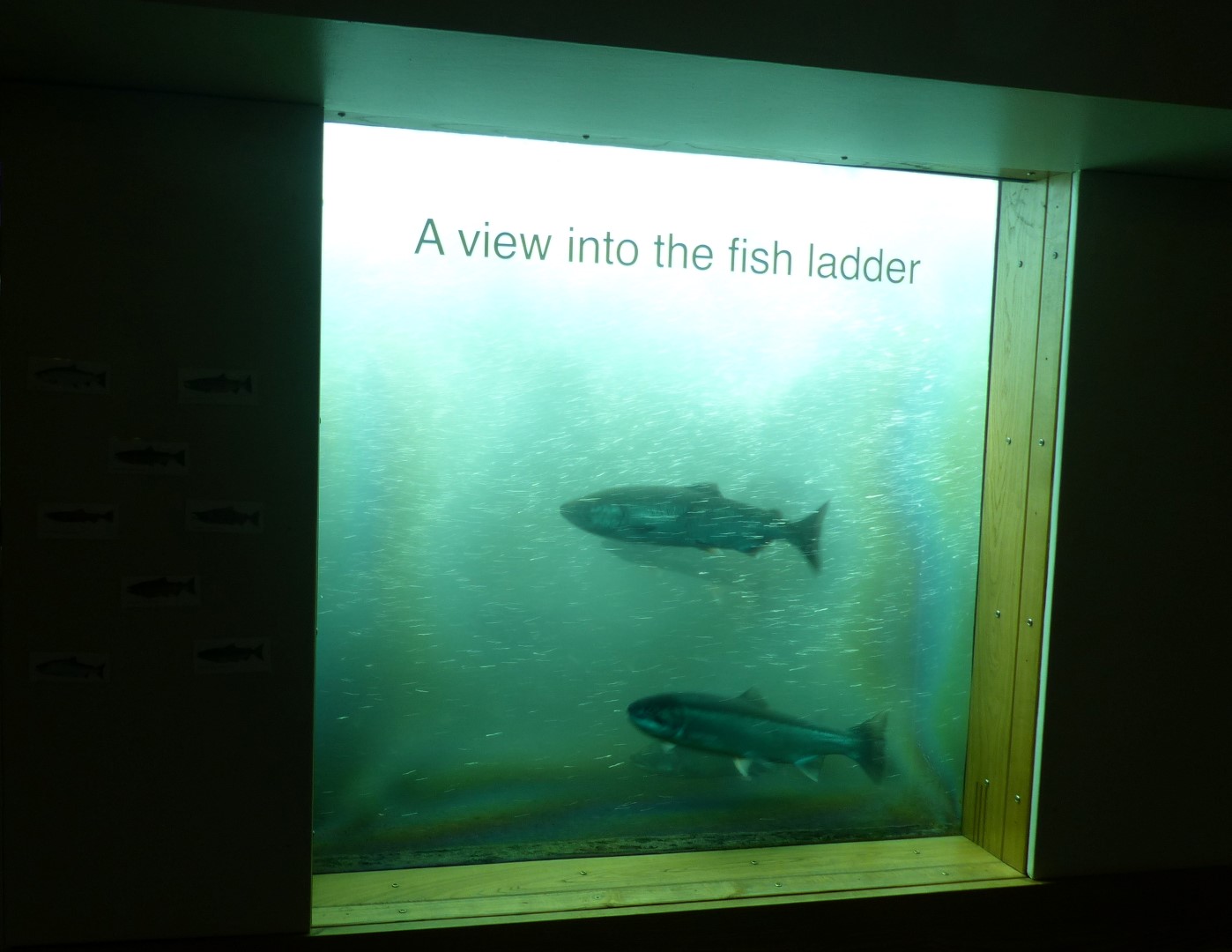
salmon run. Every year in the Columbia River, thousands of Sockeye, Coho, and Chinook Salmon migrate back to their native waters to lay their eggs to begin their life cycle over again. Once a salmon is hatched, they will spend the next 1 to 6 years of their life in the ocean until it is time for them to lay their eggs where they will begin their journey to the same rivers and stream where they were hatched. It's an incredible story of the perseverance, endurance and instinct of these creatures. It has been documented some have traveled over 900 miles up streams and 7000 feet in elevation to lay their eggs. Once they spawn, they will die shortly thereafter. There have been 8 dams built on the Columbia and "fish ladders" have been installed in all of them. The
Bonneville Dam we visited near the town of
The Dalles has such a ladder, and also an underwater viewing area to watch the Salmon navigate the ladder. Here's a
link to You Tube video that shows the fish going through the ladder. There is a narrow section of the ladder forcing the fish to travel by a window where someone actually counts the salmon going through the ladder.
Friday, we're pulling up stakes again and plan to travel to the Pacific Coast to the town of
Long Beach, Wa. where we have reservations at
Cranberry RV Park for three or more days. We're looking forward to partaking of some of that good seafood we find along the coast lines.
 |
| Our location in Goldendale, Wa. |
 |
| Sign at entrance to park. |
 |
| Our site, #20. We had 30 amps power with no sewer, but we managed OK. Rate was $30/night and were fortunate to find anything. |
 |
| Pretty view inside park. |
 |
| Taken from boat landing of Maryhill State Park, adjacent to our park. The Columbia River is huge, and is much larger 200 miles downstream where it empties into the Pacific. |
 |
| Kathy wanted to see if the water was cold while Crickett was busy taking pictures. |
 |
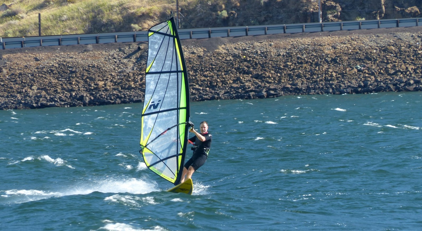
| Wind surfing is very popular on the Columbia when the wind is favorable. |
 |
| The wind surfers we spoke with told us there can be swells in the river as high as 8 feet when the wind is really blowing, much like the ocean. |
 |
| Many orchards are grown in this area. If you look real close you can see Mount Adams in the top right quadrant of the photo. |
 |
| Here's a little closer view. |
 |
| There are many fishermen trying to take advantage of the Salmon Run. |
 |
| Closer shot of Mt. Adams. It stands at over 12,000 feet and is the second highest mountain in Washington, behind Mt. Ranier. |
 |
| Mount Hood, which stands at 11,250 and is the tallest mountain in Oregon. It's near Hood River. In certain areas you can see Mt. Adams and Mt. Hood from the same location but are too far apart to get in the same picture. (Kathy's photo) |
 |
| Restaurant and Visitor Center at Cascade Locks on the river. |
 |
| This area is supposed to be home to Bigfoot! |
 |
| The Columbia Gorge paddle wheeler. Cruises can be taken on her from Cascade Locks |
 |
| Lewis and Clark traveled this exact area on their exploration in the early 1800's. They had a Newfoundland dog on their trip named Seaman and was used for warding off bear and buffalo, They also had a female Native American named Sacagawea who had a young child with her. The presence of the teenage mother with the party showed their peaceful intentions to tribes along the way. Their statues have been erected in a park in Cascade Locks. |
 |
| Lock at Bonneville Dam |
 |
| Watching the salmon go through the fish ladder was really cool. |
 |
| They actually keep a running total of fish going through the ladder by species. |
 |
| Entrance into the famous Multnomah Falls. The parking area for the falls is in the median of I-84 with an underground walkway under the eastbound lanes and is a short walk to the falls. |
 |
| The falls are spectacular and are the fourth highest in the country. |
 |
| We climbed to the bridge for the full effect! |
 |
| Shot taken from the bridge looking down into lower falls. |
 |
| Pretty reflection from setting sun in one of the pools. |
 |
| Cascade Locks |
 |
| Bridge of the Gods crossing the river from I-84 to Highway 14. The bridge was completed in 1926. There is a $2.00 toll to cross the bridge |
 |
| Shot of Bonneville Dam, which is in two sections. |
 |
| Did I mention trains are plentiful here? I shot this one inside Terry and Kathy's Jeep going east on Highway 14. |
 |
| There are some barges on the river here, but nowhere near as many or as large as we saw on the Mississippi. |
 |
| There are many farms of wind turbines on the top of the gorge. |
 |
| A replica of Stonehege was built here to honor the servicemen of Klickitat County that lost their lives in World war I. It was dedicated in 1926. |
 |
| Many fishermen on the river. Guess what's in the background.......Yep another train! Btw, Native Americans in the region can catch all the fish they can eat and are allowed to use gill nets. Everyone else has a one or two fish limit. |
 |
| Older Bridge near Hood River. |
 |
| There is a 35 mile loop of orchards and fruit stands near Hood River. The route is called "Fruit Loop". This one was called the Draper Girls and had a good variety of many kinds of fruit at reasonable prices. They also have a "pick your own" where you can go into the orchards and pick your own fruit. |
 |
| I thought the flowers were pretty in the late day sun. |
 |
| Deschutes River south of The Dalles. It's on the Warm Springs Tribal Reservation. |
 |
| Sherar's Falls on the Deschutes River. Notice the platforms on the far side of the river which are used by Native Americans to net salmon as they go upstream. |
 |
| Upper section of Sherar's Falls. Notice the fish ladder beside the falls. |
 |
| Captured this Raven in parking lot near Hood River while shopping. |


We stayed at Peach Beach also. Saw the orchards & Stonehenge replica. Lovely area. Saw the falls but didn't climb! Love traveling with y'all! Betty
ReplyDeleteHow amazing! Cliff and I have so enjoyed your wonderful blog and phenomenal pictures. We can't wait to plan our first trip and your experiences have made us so excite to see this beautiful country we live in. Thank you for sharing your journey, it is incredible. Safe & Blessed Travels. Cliff & Nancy
ReplyDelete